Main results of the experimental and theoretical research completed in 2011
|
|
An automated method for mapping of vegetation cover over Russia using Earth observation data
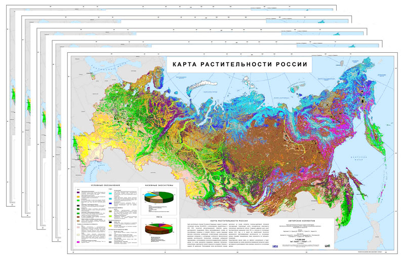
New automated method has been developed for mapping of vegetation cover using the Earth observation data acquired by the spectroradiometer MODIS. The method involves cloud and cloud-shadow screening and generation of multi-annual time-series of surface reflectance data, which are used for land cover types classification based on locally-adaptive algorithm.
The method gives an opportunity for unified mapping of vegetation over large territories without preliminary stratification, which opens the possibility of its potential use at any, up to global, geographical coverage.
The TerraNorte RLC land cover map for Russia with 250 v spatial resolution has been developed based on described above method. The map legend consists of 22 thematic classes; including 18 classes to describe various vegetation types classified taking into account their life forms, leaf types and phenology.
The method made a basis for development of the automated technology for dynamic land cover mapping, which has been used for production of time-series of annual land cover maps of Russia for the period starting from 2000 until now.
Developers:
- The Space Research Institute of Russian Academy of Sciences
- Bartalev S.À., DrSc, phone +7 495 333-53-13, e-mail: bartalev@smis.iki.rssi.ru
- Loupian Å.À., DrSc, phone +7 495 333-53-13, e-mail: evgeny@smis.iki.rssi.ru
- Egorov V.À., PhD, phone +7 495 333-53-13, e-mail: egorov@smis.iki.rssi.ru
- Uvarov I.À., PhD, phone +7 495 333-53-13, e-mail: uvarov@smis.iki.rssi.ru
- Plotnikov D.Å., phone +7 495 333-53-13, e-mail: dmitplot@smis.iki.rssi.ru
- The Center for Forest Ecology and Productivity of Russian Academy of Sciences
- Isaev À.S., academician, phone +7-499-743-0025, e-mail: isaev@cepl.rssi.ru
- Ershov D.V., PhD, phone +7-499-743-0025, e-mail: ershov@ifi.rssi.ru
 |
| Time-series of land cover maps for Russia based on Terra-MODIS data |
Publications:
- Bartalev S., Egorov V., Ershov D., Isaev A., Loupian E., Plotnikov D., Uvarov I. Satellite mapping of the vegetation cover over Russia using MODIS spectroradiometer data // Contemporary Remote Sensing from the Space, 2011. Vol.8. Issue 4. P.285-302. (in Russian)
- Bartalev S., Egorov V., Loupian E., Plotnikov D., Uvarov I. Recognition of arable lands using multi-annual satellite data from spectroradiometer MODIS and locally adaptive supervised classification // Computer Optics, 2011. Vol. 35. Issue 1. P.103-116. (in Russian)
- Plotnikov D., Bartalev S., Loupian E. The recognition features to map arable lands based on multi-annual MODIS Earth observation data // Contemporary Remote Sensing from the Space, 2010. Vol.7. Issue 1. P.330-341. (in Russian)
- Uvarov I. and Bartalev S. The algorithm and software suite for land cover types recognition based on locally-adaptive supervised classification of satellite imagery // Contemporary Remote Sensing from the Space, 2010, Vol. 7. Issue 1. P. 353-365. (in Russian)
- Bartalev S., Ershov D., Isaev A., Loupian E. Main tasks and perspectives for development of global forests satellite monitoring system // Forest Science, 2011. Issue 6. (in Russian)
Forecast of upcoming geomagnetic storm magnitude
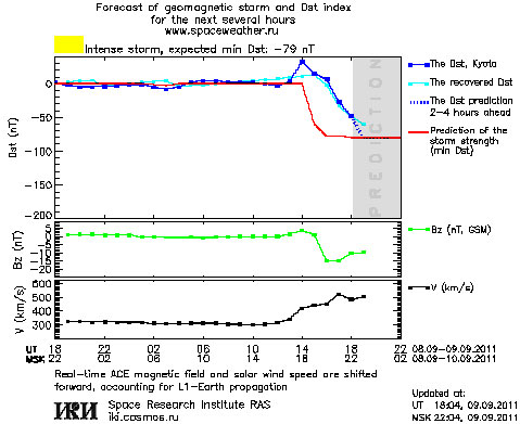
The new forecast method of upcoming geomagnetic storm is developed, allowing to predict its magnitude 4-10 hours in advance. Parameters of geomagnetic storms are determined be solar wind and interplanetary magnetic field, affecting Earth’s magnetosphere. Storm development has cumulative nature and takes several hours after first appearance of interplanetary disturbance. Thus a forecast can be issued up to 4-10 hours in advance relative to standard prediction period of about one hour, given by a distance between Earth and solar wind monitoring point 1.5 mln km ahead Earth. The forecast is implemented in real-time at the website of IKI ÐÀÍ www.spaceweather.ru
Authors A.A.Petrukovich, T.V. Podladchikova

“Plasma-F” experiment works in flight
On July 18, 2011 it was launched the high-apogee Russian satellite “Spectr-R”. Onboard this s/c it was placed the scientific experiment “Plasma-F” that
includes the energetic particles monitor MEP, the energy-spectrometer BMSW, the magnetometer MMFF and the acquisition scientific data system SSNI-2.
These instruments were switch on after July 05, 2011 and since this moment they (except of instrument MMFF) permanently work in flight and issue the
scientific information with the new quality under the record time resolution. Device SSNI-2 provides with the flexible control of information streams.
The ground-based scientific set (NNK) provides with fast receiving in IKI the satellite information during the connection sessions.
The first results of “Plasma-F” experiment are already published in the paper “Solar wind set riddles” by G. N. Zastenker, L.M. Zelenyi, A.A. Petrukovich,
V.N. Nazarov, L.S. Chesalin et al. in the journal “Russian Space”, #10, pp.26-31, 2011.
Main results of the experimental and theoretical research completed in 2010
Main results of the experimental and theoretical research completed in 2009
|
|

