|
|
These include satellites which monitor the weather, such as the GOES series (one of which is shown on the right) of the US National Oceanic and Atmospheric Administration (NOAA). They are in synchronous orbit, keeping the same area in view as the Earth rotates. To this class also belong "spy satellites" which observe the ground from low circular orbits. For obvious reasons they are rarely described in public, but some are said to have sizes comparable to that of the Hubble telescope. The US Air Force furthermore sponsors polar satellites of the DMSP series, scanning the cloud cover of the polar region and also studying ions and electrons of the magnetosphere. |
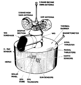
Other satellites scan the Earth for a variety of purposes: for instance, the French SPOT series of surveillance satellites mainly serves commercial customers (one SPOT observed among other things the Soviet nuclear reactor accident in Chernobyl). NASA's Polar collects images of the polar aurora (as did the Swedish "Viking" and "Freja", and several earlier satellites), and the US Landsat series was primarily meant to observe vegetation. The Canadian satellite Alouette in 1962 bounced radio signals off the top of the ionosphere, and UARS (Upper Atmosphere Research Satellite) has studied the Earth atmosphere. Satellites and instruments of the Landsat program have in the past provided extensive images and data on land use, vegetation etc. The first of a new series of NASA's Earth-observing missions, the EOS-1 missions, was successfully launched November 21, 2000.
|
Next Satellite Class: #29c Those observing local conditions
Next Regular Stop: #30 Far-out Pathways to Space: Great Guns?
Timeline Glossary Back to the Master List
Author and Curator: Dr. David P. Stern
Mail to Dr.Stern: stargaze("at" symbol)phy6.org .
Last updated: 9-24-2004